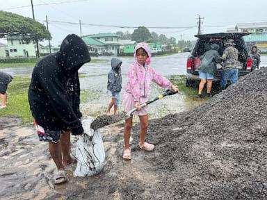
Hurricane Nolo Lashes Hawaii; Kilauea Volcano Threatens 'Volcanic Hail'
Hurricane Nolo brings rain and wind to Hawaii as Kilauea volcano shows precursor activity for 'volcanic hail'.
Millions of Hawaii residents faced hazardous weather alerts this weekend as Hurricane Nolo swirled offshore, bringing heavy rain and high winds to the Aloha State. As of Sunday morning, Nolo was a Category 2 hurricane with winds up to 105 mph, located about 200 miles south of the Big Island and moving west.
While Nolo briefly weakened to a Category 1 storm on Saturday, it re-strengthened overnight. Forecasters expected it to become even stronger and make a westward turn, with its center remaining south of the Hawaiian Islands. Outer rain bands were predicted to lash parts of the Big Island and Maui on Sunday, with intensity expected to diminish later in the day. A flood watch was in effect for the Big Island through Sunday night.
Despite the cancellation of all tropical storm alerts for Hawaii due to Nolo's weakening trend on Saturday, gusty winds, heavy rain, and large waves were still anticipated for some areas. Alerts for gusty winds remained in place for parts of the Hawaiian Islands until 6 p.m. Sunday local time.
Adding to the weather concerns, officials expressed alarm over the potential for "volcanic hail" from the Kilauea volcano. Hawaii County Mayor Kimo Alameda stated that precursor activity detected at Kilauea has placed officials on high alert for the possibility of tephra, or volcanic hail, being ejected.
Mayor Alameda described the potential tephra ejection as a significant hazard, noting it could reach up to a thousand feet and be carried by winds into surrounding communities. He highlighted the danger to water catchment systems, swimming pools, and roads, emphasizing that the accumulation could reach a disaster threshold if not managed.
Emergency officials are closely monitoring the volcanic activity to determine if it will progress. The current situation at Kilauea is particularly concerning given the ongoing hurricane conditions affecting the Big Island, presenting a dual threat to residents.
Nolo is one of three hurricanes currently active in the Pacific. Hurricane Polo, a major Category 3 storm with 120 mph winds, was forecast to bring tropical storm conditions to Baja California Sur. Hurricane Odalys, a weakening Category 1 storm, was expected to turn south and dissipate.
The simultaneous presence of three Pacific hurricanes is a rare event. The last instance of three active hurricanes in the Pacific occurred in 2015, with Kilo, Ignacio, and Jimena. The current meteorological conditions underscore the active tropical season in the region.
This article was written by AI based on publicly available news reporting. Original reporting by the linked source.