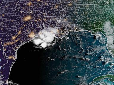
Tropical Storm Edouard May Become Hurricane Before Striking Gulf Coast
Tropical Storm Edouard is poised to strengthen to hurricane strength before making landfall on the northwestern Gulf Coast Tuesday.
Tropical Storm Edouard is expected to significantly intensify and potentially reach hurricane strength before making landfall along the northwestern Gulf Coast on Tuesday, September 1, 2026. The National Hurricane Center has issued tropical storm warnings and a hurricane watch for coastal areas of Texas and Louisiana, near the state line.
Warm sea surface temperatures in the Gulf of Mexico, which are 2 to 4 degrees above average, are providing favorable conditions for Edouard to strengthen. The storm is forecast to make landfall around 1 p.m. to 2 p.m. CT Tuesday, likely near the Louisiana-Texas border.
Edouard is projected to bring rainfall totals of 3 to 6 inches across the region, with isolated areas potentially receiving up to 9 inches, particularly in inland parts of the Upper Texas Coast through east-central Texas. Southwest Louisiana could see 2 to 4 inches of rain, with the heaviest precipitation anticipated in rural areas between Houston and Beaumont.
The anticipated rainfall raises concerns about flash flooding, especially in low-lying and urban areas. River flooding is also a possibility. Forecasters expect winds of 70 mph or greater near the storm's center at landfall, with the storm expected to weaken rapidly after moving inland.
Storm surge is another significant threat, with predictions of 3 to 5 feet from High Island, Texas, to the Vermilion-Cameron Parish line in Louisiana. Additionally, there is a risk of one or two tornadoes developing Tuesday afternoon and evening over parts of southwest Louisiana and southeast Texas.
Officials are urging residents in the affected areas to prepare for the storm's impact. Floodwater safety tips are being disseminated, emphasizing the dangers of driving or walking through flooded areas. The rapid strengthening of Edouard underscores the importance of staying informed about weather alerts and heeding evacuation orders if issued.
The storm's development highlights the volatile nature of tropical systems in the Gulf. The above-average sea surface temperatures create an environment where storms can quickly gain strength, posing a greater threat to coastal communities. This year's hurricane season has already seen several systems develop, and Edouard's potential to reach hurricane status serves as a reminder of the ongoing risks.
As Edouard approaches, authorities are monitoring its trajectory and intensity closely. The focus remains on ensuring public safety and minimizing potential damage. Further updates on the storm's path and strength will be provided by the National Hurricane Center.
This article was written by AI based on publicly available news reporting. Original reporting by the linked source.