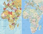
UN to Vote on New World Map Accurately Showing Africa's True Scale
The UN General Assembly will vote on a resolution to phase out the Mercator map, which distorts Africa's size, in favor of a more accurate representation.
The United Nations General Assembly is poised to vote on a resolution that could lead to the formal phasing out of the traditional Mercator world map, a projection that has long distorted the perceived size of Africa and other equatorial regions. The resolution, sponsored by Togo and supported by the African Union's 54 member states, aims to adopt a map that more accurately reflects the true scale of the African continent.
This proposed shift stems from a growing awareness that the Mercator projection, created by Flemish cartographer Gerardus Mercator in 1569, significantly underrepresents areas near the equator while exaggerating the size of regions closer to the poles. For centuries, this map has served as the global standard for navigation, education, and technology, inadvertently perpetuating a skewed global perspective.
Robert Dussey, Togo's foreign affairs minister, emphasized the scientific basis of the resolution, stating that the discussion is rooted in verifiable data rather than political considerations. He noted that the Mercator map incorrectly depicts Africa as being roughly the same size as Greenland, when in reality, the continent is approximately 14 times larger than the Danish territory. Activists highlight that the United States, China, India, Japan, Mexico, and a significant portion of Europe could fit within Africa with room to spare.
While UN resolutions are non-binding, a positive vote could significantly influence educational curricula, technological applications, and public understanding of global geography. The #CorrectTheMap campaign, which has garnered over 11,000 signatures on Change.org, has been instrumental in raising awareness and pushing for this change. The African Union officially endorsed the campaign in August 2025, tasking Togo with leading the initiative at the UN.
Historians and geographers have long pointed out that the Mercator projection, despite its utility for navigation, is rooted in colonial-era perspectives. Critics argue that its inaccuracies reinforce Western-centric views of the world, a phenomenon some have termed "cartographic colonialism." The disproportionate representation of landmasses can subtly influence perceptions of power and importance.
The African Union's endorsement underscores a continental desire to reclaim accurate representation and challenge historical cartographic biases. By advocating for a more equitable depiction of land, the union seeks to foster a more informed global understanding of Africa's vastness and its place on the world stage.
The debate over the Mercator projection is not new, with various alternative maps, such as the Gall-Peters projection and the Equal Earth map, having been proposed over the years to offer more geographically accurate representations. The Equal Earth map, for instance, is often cited for its visually balanced portrayal of the continents.
If the resolution passes, the practical implications will likely unfold over time, potentially leading to the updating of digital mapping services, educational materials, and official government charts. The vote represents a significant moment in challenging long-held visual conventions and promoting a more scientifically accurate and equitable global perspective.
This article was written by AI based on publicly available news reporting. Original reporting by the linked source.